Fleety - Subway & Bus Tracker
- 4.2
- Rating
- 10.00K
- Installs
- Free
- Price

 Analysis by App-foxy
I installed Fleety to see how it handles the part of public transport that usually causes the most stress: figuring out whether the next bus or train is actually worth waiting for. It is a free Maps & Navigation app from Global Transit Inc., built around transit tracking for MTA, CTA, LA Metro and UTA services. The idea is simple, but the usefulness depends heavily on where you are, how good your connection is, and whether you need live information or just a timetable.
My overall impression is that Fleety is most helpful as a quick decision-making tool. I would open it before leaving a station, while walking to a stop, or when deciding whether to wait for a delayed service or choose another route. It is not trying to replace every mapping app on your phone. Instead, its appeal is a more focused view of transit movement, arrival times and schedules in the systems it covers.
The app has an average rating of 4.2 from around 344 ratings and has passed 10 thousand installs. Those figures suggest a small but active audience rather than a long-established mainstream platform. Its Everyone content rating makes it suitable for a broad range of riders, including families and occasional public transport users. The current version is 0.49.1, and it runs on Android 7.0 or later.
You May Also Like

 Blood Strike: 2.5 Anniversary
Blood Strike’s Loadouts Turn Every Drop Into a Tactical Gamble
A close look at Blood Strike’s custom loadouts: how fast access to signature weapons reshapes its battle royale rhythm, rewards preparation, and narrows the gap between fights.

 Pandora - Music & Podcasts
Pandora’s Music Is Easy to Start, but Harder to Recover
Pandora’s strength is its low-effort path from a seed to a station. Its weak spot is how much confidence it asks you to place in connection, setup, and quiet recovery.

 8 Ball Pool
 Is Built on Rivalries, Rematches, and Routine
A close look at the rivalries, rematches, shared routines, and unanswered safety questions that turn a quick pool match into a persistent mobile community.

 Samsung Music
’s Quiet Strength Is Playing What You Already Own
Its reach comes less from spectacle than from dependable access to a personal library. That simplicity is both the app’s strongest retention engine and its ceiling.

 AccuWeather: Weather Radar
AccuWeather Review: A Quick, Clear Forecast for Everyday Decisions
For everyday plans, the best forecast is the one you can understand quickly. AccuWeather makes rain timing, radar, and local conditions easy to act on, with a few trade-offs.

 Hill Climb Racing
Why Hill Climb Racing Still Turns Crashes Into One More Run
A tiny car, a bumpy hill and one more upgrade: Hill Climb Racing keeps resurfacing because its simple chaos makes every near-miss feel personal.
More From Our News Desk



How Fleety behaves when your connection matters
I treat a weak connection as a cue to change how I use the tracker, not as proof that a service has stopped running. Checking the route and schedule before heading underground gives me a useful reference point, while a quick comparison with the timetable helps when a live estimate looks doubtful. That approach makes the handoff from planning on screen to travelling in the real world less brittle.
Live information is useful only when the network is cooperating
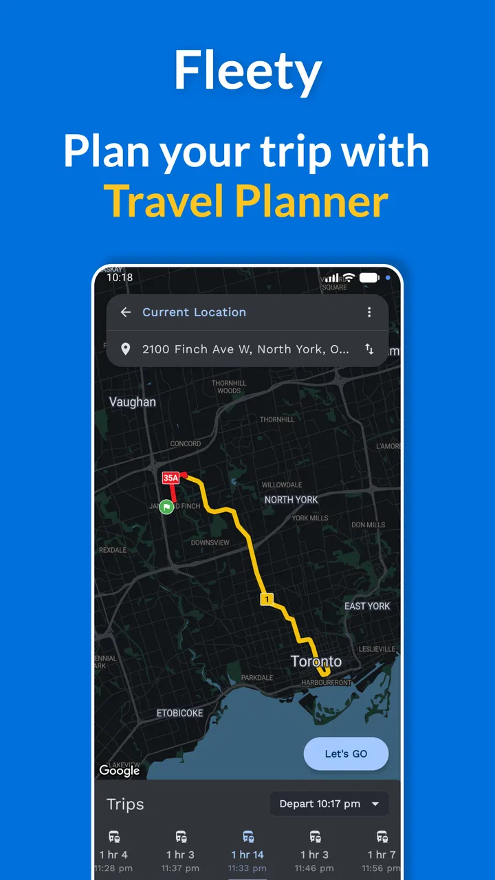
The central experience revolves around live maps, arrival times and schedules, so connectivity is not a minor detail here. When the app can reach its transit information, the map view becomes much more useful than a static route list. I can check the nearby service, look at the expected timing, and make a practical choice instead of relying entirely on a printed timetable or memory.
That strength also creates a clear trade-off. A live transit tracker is only as current as the information it can retrieve. In a station with weak reception, inside a tunnel, or during a crowded commute when the mobile network is struggling, the experience may feel less immediate. I would not treat the app as a guarantee that a vehicle is physically about to arrive. I use the displayed timing as guidance, then leave a little room for normal transit uncertainty.
This is especially important for a tight connection. If I have a meeting in ten minutes, I would not use one arrival estimate as permission to cut the timing dangerously close. Fleety is better at improving a decision than eliminating risk. It can tell me which service looks more promising, but it cannot control delays, platform changes or a sudden service interruption.
A realistic commute workflow
Imagine leaving work in the afternoon and walking toward a station served by one of the supported networks. I would open Fleety before entering the station, check the map and compare the next displayed times with the schedule. If the closest service appears far away, I can decide whether to walk to another stop, wait where I am, or use a familiar alternative.
The useful part is the timing of that check. Looking before I reach a poor-signal area gives me more room to react. I would also avoid repeatedly refreshing the app while standing underground. A better habit is to check once while connected, remember the relevant service and platform direction, then use the result as a plan rather than constantly demanding new data.
This workflow reveals one of Fleety’s less obvious advantages: it encourages a small amount of planning without requiring a full journey-planning session. I do not always need turn-by-turn directions. Sometimes I only need to know whether waiting for the next bus makes sense. For that narrow question, a focused transit screen can be quicker than navigating through a larger all-purpose maps app.
Using it while moving around a city
Fleety makes the most sense for riders who regularly use MTA, CTA, LA Metro or UTA services. If I live in or frequently visit one of those transit areas, the app can become a practical pre-departure check. It is also useful for visitors who already know their general destination but need a clearer view of the local bus or subway timing.
For a visitor, I would recommend checking the route before leaving a hotel or café, where the connection is likely to be more dependable, rather than waiting until the middle of a transfer. That small change in routine reduces the chance of being stuck with a blank or outdated view at exactly the wrong moment.
The app is less attractive for someone who moves between many cities and expects one universal transit tool. Its supported systems are specific, so the value is strongest inside those networks. If your daily travel depends on a local agency outside that group, a city-specific application or a broad mapping service may serve you better.
What happens when information does not load smoothly
One of the first things I look for in a transit app is how easy it is to recover from a weak connection or an interrupted session. With Fleety, I would approach a loading problem practically: move to a place with better reception, reopen the relevant view, and compare the result with the schedule rather than assuming the first failed attempt means the service itself is unavailable.
That recovery habit matters because public transport apps are often used in awkward locations. A station entrance may have interference, a bus may pass through a dead zone, and a phone may switch between networks while I am walking. The app cannot make those conditions disappear. What it can do is remain useful when I treat live information as something to check at sensible points during the journey.
I would also keep a backup mental plan for an important trip. Before boarding, I note the direction and approximate service I am taking. If the screen stops updating during the ride, I am not completely dependent on the app to know what I am doing. This is not a criticism unique to Fleety; it is a sensible way to use any network-dependent tracker.
The limitation is more noticeable for riders who expect instant certainty. Fleety’s focus on live maps and times may make a connection problem feel more frustrating because the most valuable information is precisely what becomes harder to reach. If you often travel through underground sections or rural stretches with unreliable mobile service, a timetable you already know or a transit app with information available in a different format may be a safer companion.
Being careful with mobile data
Because the app presents maps and live transit information, I would use it thoughtfully when travelling on a limited mobile plan. The practical approach is to open it when necessary instead of leaving the map running for an entire journey. Check the service before departure, confirm the next decision point, and close it once you have enough information.
That approach also makes the app feel less demanding. A transit tracker does not need to be a constant background companion for every rider. If I already know the route, I may only need one timing check. If I am exploring an unfamiliar part of a city, I may check at each transfer, preferably while connected to a reliable network.
I would not assume that a previously viewed map or schedule will remain current after the connection disappears. Static information can become stale, and live estimates are particularly sensitive to changes. The safest interpretation is that a result is useful for the moment it was retrieved, not a permanent promise for the rest of the trip.
There is also a privacy-conscious benefit to a restrained workflow: I am opening the app for a specific transit decision rather than continuously watching a moving map. I still use the tool for what it does best, but I avoid turning every ride into an unnecessarily active data session.
Where it fits beside familiar alternatives
Compared with a general mapping app, Fleety feels more focused. A larger maps platform may be better when I need walking directions, driving options, business information or a complete door-to-door plan. Fleety’s advantage is the narrower transit view: it puts the supported public transport systems at the center rather than treating them as one layer among many.
Compared with an agency-specific app, the choice depends on coverage and habit. A local authority’s own tool may be preferable for riders who want every official notice in one place. Fleety is more appealing when I want a compact tracker across its supported services or prefer a straightforward transit-oriented interface.
Compared with relying on a schedule alone, Fleety has the obvious advantage of live context. A timetable tells me what should happen; a live view can help me judge what appears to be happening now. That distinction is valuable during a busy commute, but it also means I should not ignore the schedule when live information is delayed or unavailable.
The app is free to download, although in-app purchases range from around three dollars to around twenty dollars per item. I would consider the free entry point useful for trying the basic experience first. Before paying for anything, I would make sure the supported network matches my routine and that the available tools solve a problem I actually have. Occasional riders may not get enough extra value from optional purchases to justify them.
Who will get the most from Fleety
I think Fleety is a good match for regular riders who use MTA, CTA, LA Metro or UTA and want a quick way to inspect transit timing before making a move. It is also suitable for commuters who already understand their city’s basic routes and need better moment-to-moment awareness rather than a complete introduction to public transportation.
It can help students, workers and visitors who make short decisions repeatedly: wait or walk, board now or take the next service, stay on this line or look for another option. Those small choices are where a live tracker earns its place on a phone.
I would be more cautious about recommending it to someone who needs guaranteed accessibility information, highly detailed disruption guidance or comprehensive coverage beyond the listed transit systems. I would also look elsewhere if my main need were driving navigation, walking directions or a single official source for every local announcement.
Small habits that make the app more dependable
My first tip is to check before entering a low-signal environment. A result obtained at street level can be more useful than trying to load the same information after descending into a station. My second is to compare live timing with the schedule when the estimate looks surprising. A single unusual result deserves a second look before I change an important plan.
My third tip is to use Fleety at decision points rather than continuously. Open it before leaving, again before a transfer, and once more when a delay changes the plan. This keeps the experience focused and is a sensible way to limit unnecessary mobile-data use.
Finally, I would keep a simple fallback for important journeys: know the direction, recognize the destination stop, and allow extra time. That does not reduce Fleety’s usefulness. It puts the app in the right role—as a helpful live reference, not the only thing standing between me and my destination.
My connectivity verdict
Fleety is a focused transit tracker with a clear purpose, and I like it most when I use it to make quick, informed choices inside its supported networks. The live map, arrival information and schedules are more useful than a static timetable when the connection is stable, especially during ordinary city commutes where a few minutes can change the best decision.
Its main weakness is inseparable from that purpose: the experience is less dependable when the network is poor, and live timing should never be treated as absolute. Riders who understand that limitation will get more from the app than people expecting a complete offline travel solution or a universal navigation replacement.
Global Transit Inc. has positioned the app as a practical Maps & Navigation option rather than an all-purpose travel suite. At no cost to start and with an Everyone rating, it is easy to try. I would recommend Fleety to anyone who regularly rides MTA, CTA, LA Metro or UTA and wants a fast transit check before and during a trip. I would skip it only if my city is outside its coverage, my journeys depend on uninterrupted connectivity, or I need broader navigation tools than a dedicated transit tracker provides.
FAQs for Fleety - Subway & Bus Tracker
01What is Fleety - Subway & Bus Tracker used for?
Fleety - Subway & Bus Tracker is designed to help you plan and manage public transportation journeys. It can provide information about subway and bus routes, nearby stops or stations, schedules, and possible connections, depending on the supported city and transit network. It is especially useful when you need to compare routes, estimate travel time, or find a practical way to reach a destination.
02Does Fleety support every city and public transportation system?
No, coverage depends on the locations and transit agencies supported by the app. Before downloading or relying on Fleety for a trip, check whether your city, subway network, and bus operators are included. Transit data can also vary by region, so some features may be more complete in certain locations than others. Availability may change as new networks are added.
03Can Fleety show live bus and subway arrival information?
Fleety may provide real-time arrival updates when the relevant transportation agency makes live data available. However, not every route or station necessarily supports this feature, and displayed times can be affected by traffic, service disruptions, GPS limitations, or delays in the agency’s data feed. Treat arrival predictions as helpful estimates and verify important travel information when necessary.
04Does Fleety work without an internet connection?
Fleety generally works best with an active internet connection because route searches, service alerts, schedules, and real-time vehicle information may need to be retrieved from online transit data. Some previously loaded information might remain temporarily available, but you should not assume that complete offline navigation is supported. For dependable use, open the app before leaving and keep mobile data or Wi-Fi available.
05Is Fleety - Subway & Bus Tracker free to download and use?
The download and available features may depend on the version of Fleety offered for your Android or iOS device. Some functions can be free, while optional upgrades, advertisements, or in-app purchases may apply. Review the store listing and the permissions requested before installing. Also remember that using mobile data, location services, or background updates may contribute to your carrier’s data and battery usage.
Pros
- Real-time arrivals help reduce waiting at stations and bus stops.
- Clear route maps make transfers and nearby connections easy to understand.
- Favorites provide quick access to frequently used lines and stops.
- Service alerts can warn you about delays
- closures
- and route changes.
- Useful for planning trips across multiple public transport networks.
Cons
- Coverage and real-time data quality vary significantly by city.
- Some features may require location access to work accurately.
- Arrival predictions can be unreliable during disruptions or heavy traffic.
- The interface may feel crowded when several routes overlap on the map.
- Battery and mobile data usage can increase with continuous location tracking.

Fleety - Subway & Bus Tracker
Gallery